 Web Cams
 Lifts & runs
We love ourselves some powder at Eagle Point.
Guests who are accustomed to skiing untracked powder with no lift lines often speak of the “Eagle Point vortex.” This mysterious phenomenon, similar to the weather quirks of Little Cottonwood Canyon or Grand Targhee in the Tetons, frequently buries our section of the Tushar Mountains in snow. Storms from the northwest, and especially from the southwest, can dump seemingly endless amounts of snow on our slopes in rapid 24-48 hour bursts. So what exactly is this vortex? Is it the Beaver River Canyon creating it? The altitude? Some people think it is the 12,000 foot “catcher’s mitt” ridegline looming above us. Honestly, we don’t have the answers—we’re not that clever. But we do know where to find forecasts from people who are.
And thankfully our slopes at Eagle Point are steep enough to allow for skiing and riding in the deepest snow mother nature throws at us.
Whether you are a true powderhound chasing dreams, or a family looking to create fresh memories while carving fresh tracks, here are helpful links to obsess over snow forecasts.
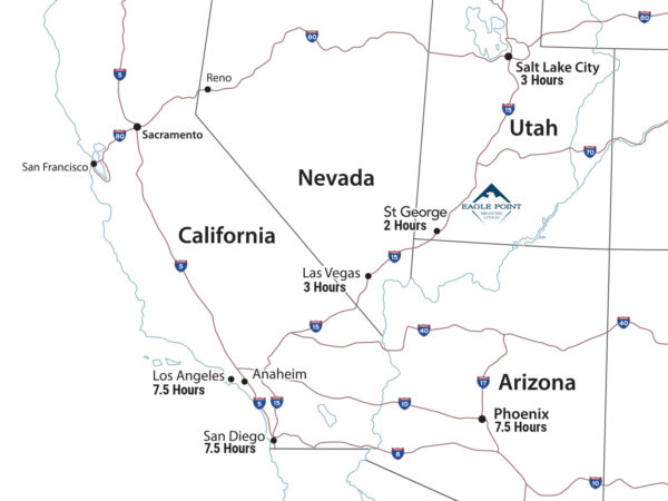
First, this is where Eagle Point is located:
Open Snow
The folks at Open Snow do an amazing job of breaking down the forecasts provided by the National Weather Association, and other meteorological models, to provide detailed daily forecasts and break out the crystal ball to examine the possible storm patterns developing 2-3 weeks on the horizon.
Evan Thayer produces the Utah Daily Snow, and its pretty much a must-read.
It is also worth following some of the other Open Snow Forecasters that focus on the Tahoe and Colorado regions. While they won’t often point to and analyze southern Utah specifically, they each offer unique perspectives, intelligible insights into what they are seeing, and additional graphs, charts and other visuals that provide a nice overview for the entire west. Check out the Tahoe Daily Snow and the Colorado Daily Snow to sharpen your own forecasting skills and glean insights into what is coming. Plus, if NorCal is getting snow and Colorado is forecasted to get snow, well, you know what’s right in between the two…Eagle Point in Beaver, Utah.
WPC Probabilistic Winter Precipitation Guidance.
Bags packed and plenty of gas in the car? The National Weather Service provides the percent chance of precipitation in the next 48 hours.
National Centers for Environmental Prediction
A great, straight forward look ahead at what the next two weeks will bring in terms of precipitation. The forecast is measured in liquid precipitation in inches. A good rule of thumb is that 1” of liquid = 12” of Utah’s Greatest Snow on Earth® for Eagle Point.
White is sad, blue is happiness, green is awesome, and yellow/orange/red means inform your boss that you will be taking a sick day soon.
Click here for a direct link to the Two Week Forecast
GFS: 10-Day Forecast
For a quick look into the future, this is a great website for daily precipitation forecasts 10 days out. The Global Forecast System (GFS) is a National Centers for Environmental Prediction (NCEP) weather forecast model that generates data for dozens of atmospheric and land-soil variables, including temperatures, winds, precipitation, soil moisture, and atmospheric ozone concentration. The system couples four separate models (atmosphere, ocean model, land/soil model, and sea ice) that work together to accurately depict weather conditions.
Click here for a direct link to the GFS 10-Day Forecast
National Weather Service GFS Model
Veteran powderhounds know all about the Global Forecast System (GFS) weather model from the National Centers for Environmental Prediction.
The NWS isn’t known for creating the easiest user interfaces for the public, but if you click on this link and then click on either “Loop All” or “Day 16” in the lower right, you will be magically transported into the future where you can track storms and their anticipated precipitation amounts across the country. It is very difficult for even the best in the world to predict the weather 16 days out, but they are usually fairly accurate in at least predicting if regional weather will be quiet or if we should get excited.
You can play around and toggle with the “Precip Params” to change the map so that it will produce total precipitation amounts over given timeframes—from 1 hour to 60 hours. The link below shows anticipated amounts during a 36 hour timeframe. We get excited when we see blues and purples over southern Utah